I rode in the park today, and followed a different route than the one we'll take next week. It was windy, fairly cloudy and cool for Bonaire. There were flamingos on the salt flats near the entrance, but hardly any at Slagbaai. I've been in the park 3 Saturdays in a row now, and the flamingos seem to be consistently in the same places. I may try to get some flamingo pix next week. There were also lots of goats, and two cats; all of whom ran away as soon as they saw me.
I've become enthused about GPS receivers, after working with them again on our recent TWR antenna profiling project. I found some software that has allowed me to digitize and calibrate some maps I have, so I can use the computer to plot the GPS tracks of my bike rides on them. It works great and it is really cool to see exactly where I rode. I won't publish any of the maps here, 'cause there may be copyright issues.
However, the software also lets me make graphs of speed vs. time, speed vs. distance, altitude vs. time, and altitude vs. distance. Even without the map image, these graphs are really interesting. It reminds me of the TV coverage of the Tour de France where they show you the course profile at the start of each stage.
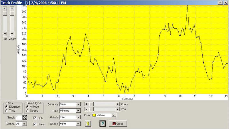
This plot is altitude versus distance. You can see that there isn't much flat riding on the roads I took. I used feet and miles here, but you can display the results in meters and Kilometers too. You can click on the picture if you want to read the fine print.
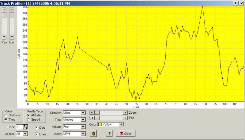
This graph shows altitude versus time. The sloping straight line from 26 to 40 minutes is from when I was stopped taking pictures. I haven't looked at the pix yet but don't expect any winners 'cause it was hazy and cloudy.

I'll probably post graphs from our group ride next week, in case any of the riders want to see or download them. The terrain will be noticeably flatter on the first half of the ride because we'll be going along the coast.
1 comment:
Ok Brad, I understand the plots, but I'm not quite sure I follow the decreasing slope (straight line) explanation. Also, is your GPS set to log data points at fixed time intervals? I have been playing around with a GPS for the last 2 years, but mainly to do a sport called "Geocaching". It is essentially a global "treasure hunt". So people hide stuff all over the world, post the coords on the 'net and others go and find them. Ok, so it sounds nuttier than it is. I think there are a couple hidden on Bonaire. The website is www.geocaching.com. Periodically I'll post some commentary about caching on my blog at http://brittonblogs.blogspot.com (shameless plug). Drop me a note if you want more details.
Post a Comment