In the photo above, you can see the Pleiades close to the lower left of the moon. Mercury is just below the dark cloud further to the lower left of the moon.Brad Swanson reports on the happenings in and around Trans World Radio's station on the island of Bonaire. TWR Bonaire broadcasts Gospel music and Bible teaching programs which can be heard in Latin America and the Caribbean: in the Spanish, English, Portuguese, Baniwa, and Macuxi languages.
You can click on the pictures to make them bigger.
Wednesday, April 29, 2009
Moon Pleiades and Mercury
In the photo above, you can see the Pleiades close to the lower left of the moon. Mercury is just below the dark cloud further to the lower left of the moon.Saturday, April 25, 2009
Site for New IBC Building
The IBC now has a nice corner lot about one block north of the Trans World Radio building where it used to hold its services and activities back in the day.
In the photo below, you can see the old church location on the right, and an arrow pointing the sign at the new location.New IBC Building is on Bonaire
The trailer had two buildings on it, one for the IBC and one for the Green Label nursery.
Johan helps load the beams onto the Gradall forklift, while Walt supervises from the ground level.
Trans World Radio employed the same Gradall to install a satellite dish a year or so ago. I've seen it busy hauling cement loads to the second floor level at building sites too, so it is a versatile machine indeed.Poo Post Update
That giant mound in the middle of the picture is the raw material, kindly donated by the Puntu Blanku chicken farm.Cool Bike Ride Logger
There are two things about MapMyRun that I find most interesting. The first thing is that you can generate an onscreen route for a ride or hike by clicking on lots of places on an onscreen map. I tried this with the Yatu Baku race loop and got just as good a result as I got when I imported a track from my GPS. So, I'm thinking that when I find an old road or trail on the satellite images of Bonaire, I might be able to create a proposed ride or hike, load it into my GPS, and then go out and try to find it in real life. There are some features that stand out on the satellite images that have proven to be pretty much invisible when you are out in the field. So this could be a big help.
The other cool thing about MapMyRun is that you can click on the link to one of my rides and see it on a fully scalable Google Earth satellite image of Bonaire. And you don't need to have the Google Earth software loaded on your computer as far as I can tell. For a while, back in the day, Google Earth wouldn't run on one friend's computer, which made it really hard to share info about bike rides with him. We've often been stuck with sending screen shot images of the rides. That isn't very useful, because the real fun happens with you zoom in on the map so you can see exactly where the path goes relative to the various, bushes, trees, and rock formations.
So please try out one of the links below and let me know if it works or not and how well. You'll need to know that the default view is of a road map, which for Bonaire looks like a big empty white blob. There is a clickable drop down box at the top middle of the map screen where you can select "Satellite Map" then you can see the track projected on Bonaire in all its glory. Also, at the top right corner of the map is a box where you can change the display from miles to kilometers, or vice versa. I really like seeing the accumulated mileage of the ride superimposed on the map.
Here is a link to the road ride I did this morning.
Here is one to a quickie mtn. bike ride I did Fri. am before work.
Here is a link to the Yatu Baku race loop.
Oh, and here is the ride I do most often after work in the evening. We call it the barf loop.
Wednesday, April 22, 2009
New Singletrack
These pictures are of a new single track section that Miguel has added to the old Yatu Baku race loop. The advanced riders will tackle the new trail section, but the rest of the riders will stick to the dirt roads of the mostly entry level race course.
This new trail is reasonably easy to ride, compared to some I've seen. Sections of the rocky Cannonball Trail, near Ringwood, NJ, come to mind. But the Bonaire trail has its own unique "charms."
The defining features of this trail are the fields of Tuna cactus and the thorny Cossie trees along the path. Even fairly minor rider errors will almost certainly result in some serious scrapes and painful punctures from those nasty barbed spines. Miguel calls these wounds, "souvenirs," proving that he is indeed the proverbial, ever optimistic, personal trainer.Bike Race on May 3
The start of the race loop is pictured above. Most of the course is nice wide dirt roads that are fun to ride. Although I have to admit that at a full-on race pace, even a gentle uphill road like this one eventually becomes killer painful. I remember the start of my first race here. I noticed that the serious racers were lining up at the start of the course in the same rear cog as I was. But they were on the big ring in front, and I had trained for the race with the middle chain ring. I knew I was in beeeg beeeg trouble.Tower Painting
The guys have figured out that I can get a good picture of them from the ground, so they were ready for me when they saw me out in the field with my telephoto lens.Sunday, April 12, 2009
Easter Weekend on Bonaire

Monday, March 30, 2009
Stars in LA
We shivered in line as we waited for the 7:45 pm planetarium show. After the show, we could have observed Saturn through the observatories 12" refractor. But the line was loooong, it was already midnight on our east coast body clocks, and also a little on the cool side for Caribbean sensibilities. Of course, if it had just been me... no line would have been too long and I would have courted pneumonia to see Saturn in that scope, but there were others to think of.LA = Car Heaven
Monday, March 23, 2009
TWR Partners Meetings
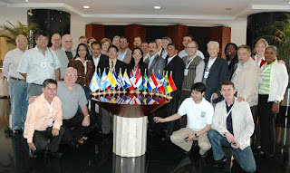
Our Bonaire station director, Joe Barker, was in Bogota, Colombia last week for the TWR Latin American partner's conference known as CRAL 2009. CRAL is an acronym for CONSEJO REGIONAL PARA AMERICA LATINA. Joe can be seen smack in the middle of the last row is this group photo.
Representatives from 14 TWR partnering countries in the Americas region took part in the sessions which featured reports and training. This was also the first opportunity for most of these people to meet Lauren Libby, the new President of TWR international.
More CRAL photos can be found on Georgina Thompson's blog.
Friday, March 20, 2009
bye bye Venus
I took the above picture back on February 27. It was on the blog together with the Moon, which was nearby at the time.Spring Has Sprung
Let's see, I think I'll give the dogs each a doggy treat to celebrate.
It is all very unsettling to Sandra, who learned a cute poem in French school about Spring starting on the 21st.
Thursday, March 19, 2009
Store Sightings

Monday, March 16, 2009
Friends from the Frozen North
Sunday, March 08, 2009
Dog Days of Winter
So So
Recently she made a slip cover for the dog's sofa bed. You see, from time to time, they decide to play with and/or chew on the cushions.... so Sandra thought that if the whole thing was covered over, the cushions would be safe.Tower Time
While Benny is on the tower, Ivan is working at clearing some of the bushes that are growing in the antenna field and interfering with the radial wires that extend radially (duh) from the base of each tower.Friday, March 06, 2009
More Feedback from Cuba
He is excited, and I think somewhat surprised, that during the first eight weeks that this new program has been on the air, he has received 276 listener responses. The map shows where the listeners are located.
Representatives from our 12 TWR partners in Latin America and the Caribbean will all be meeting in Bogota soon, so Alberto concludes, "Looking forward to seeing you soon. I have amazing histories about TWR ministry in Cuba. You have done a wonderful job in Bonaire and God has blessed your ministry here in Cuba."
Friday, February 27, 2009
Moon and Venus

Wednesday, February 25, 2009
Comet Lulin Update
Here is a web page from sky and telescope with more information about the comet and a handy dandy finder chart. The comet is pretty easy to spot in binoculars, once you know where to look, so give it a try this week before the moon gets bright.
Andrea 2
There were still lots of fish to be seen, and the coral looked good down over the dropoff. We always see squid at Andrea 2.Sunday, February 22, 2009
Comet Lulin (finally) Observed
We saw Comet Lulin for the first time Saturday night. It was super easy to spot in binoculars and I could just detect it with my naked eye from our back yard. It would have been easier to spot if we had gone to a darker location on the island, but it was too cloudy to make the outing worthwhile. That and a strong self preservation instinct that tends to keep me off the roads as much as possible during Carnival season.Moon and Planets
It was just clear enough this morning to spot the Moon, Mercury, Jupiter and Mars (in order of appearance from upper right to lower left) lined up in the sky. The picture above is one of the first ones I took, when the sky was still pretty dark and Mars was just barely visible to the naked eye. There are a few stars visible as well.
Then the clouds moved in and it was a good while 'till I got some more chances to take pictures. I needed binoculars to spot Mars by this time, but it can still be seen in the above photo.Friday, February 20, 2009
Moon and Planets

Wednesday, February 18, 2009
Google Earth
We also consulted GE on an almost daily basis last fall when we were driving all over the east coast of the USA giving presentations for Trans World Radio.
I recently came across this short but interesting article from Popular Photography that sheds a little light on how they get those great images.