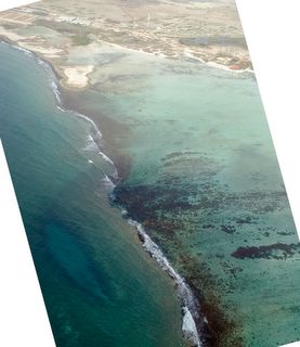
The light green water is waist deep and is the area that beginning and intermediate windsurfers sail in. More advanced sailors can venture into the blue (deeper) water extending off the lower right corner of the picture, and sail all the way over to the Cai side, if they want to.

We have flown a bit more south now and you can see the south part of the reef that extends from Sorobon to Cai and creates Lac Bay.
This view shows how just close to sea level much of the southern part of Bonaire is.
You can just see some fingerlike formations of coral inside the reef towards the bottom right edge of the picture. This is an awesome snorkeling area if there aren't too many waves.

This view is just outside the south end of the reef. The fingerlike coral formations and more can be seen right in the middle of the picture, just to the right of the waves breaking on the main reef.
At the lower left of the picture is is an oblong formation under the water that we used to call "the trench", but is more commonly known these days at "white hole." It is a sink hole of sorts in the ocean floor, and has a sandy bottom, so it looks light in color with a dark rim around it. We often see tarpon and sometimes see a nurse shark in the trench, and always see turtles and rays out past the trench as the bottom slopes away to deeper water.


I was really pleased that we could see the trench from the air. Then I had the bright idea of seeing if I could find it on the Google Earth picture of Bonaire. See my post below about Google Earth. Sure enough, you can easily see the trench on Google Earth. Just search on
12.094129N 68.228076W
The windsurfing centers can be seen at 12.093088N 68.236209W
The beach, conch piles, and buildings at Cai are at: 12.103612N 68.222346W
No comments:
Post a Comment