Tuesday, March 28, 2006

Washington Park Panorama II


I just posted another panoramic image in my Club Photo panoramas album. It is pretty cool, but I won't even try to post it here, because it is probably too big.

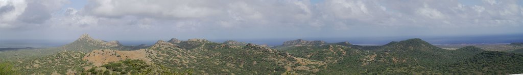
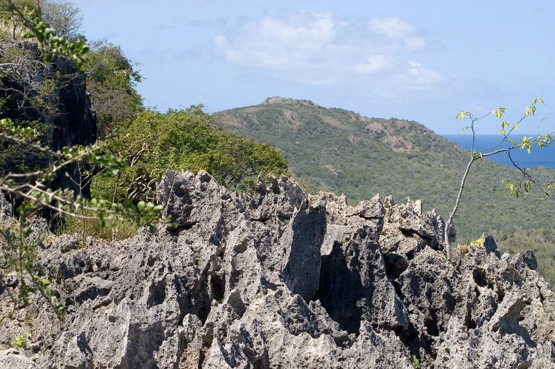
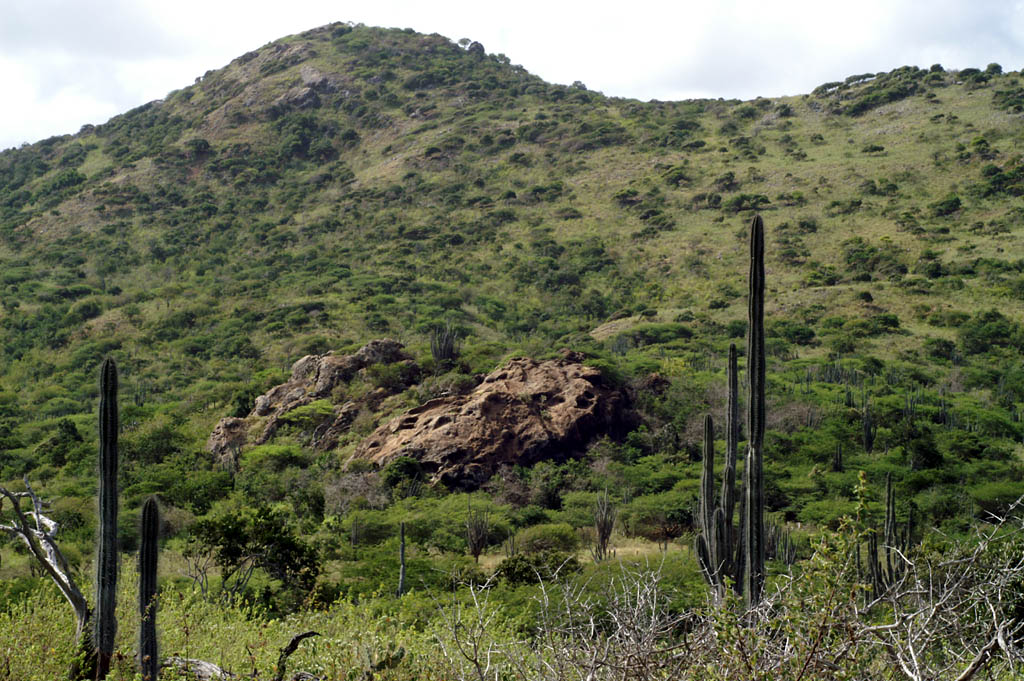
The panorama is called "WParkmiddle" because it shows an area deep in the bowels of Washington Park. I shot it freehand while standing on a big rock outcropping a hundred or so meters north of the cement roller coaster section of the road heading out of the park from Slacbaai. This rock doesn't look like much when seen from the road on the south. I've passed it zillions of times and never noticed it. But it is impressive when seen from the North. The picture here shows the rock outcropping as seen from the north side looking south. Seru Yuwana looms up behind the rock. The hillside above the right edge of the rock is the exact section I climbed to get to the top.

If you look closely in the lower left corner of the panoramic picture on the Club Photo site, you can spot a teeny bit of the cement road, and you can get a couple glimpses of dirt sections of the road as you pan a little to the right.

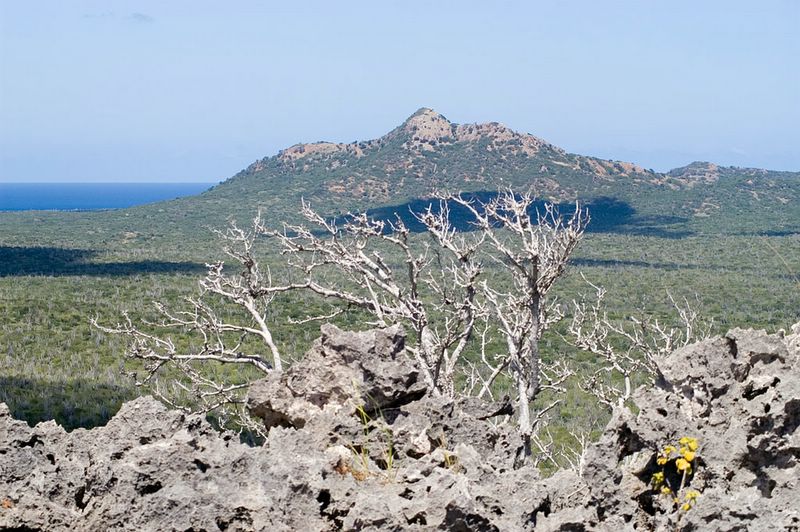
The steep hill at the left side of the panorama is not that far from where I began my climb to Seru Yuwana. There are a a number of other "peaks" in this picture that I want to climb too, partly to check out the view, but also to plot the GPS locations on my map. The area is so hilly, it is hard to be sure which hill is which.

The notch in the distance about a quarter of the way across the panorama, from left to right is the north side of Yuwana pass. You can see the south side of the pass in one of the other panoramas.

Monday, March 27, 2006

More Panoramas

Back about a month ago, Sandra and I climbed Seru Wekua and got a GPS reading at the survey marker at the top. I mentioned this briefly back on my Feb. 19 posting.

Seru Wekua is located north of Bopec. After you pass Bopec on the ridge road and are back at sea level on you way to New Cove and Playa Frans, Seru Wekua is the big hill on the right, just after the small salt flats. It's about 535 feet tall.

I've stitched together some of the pictures I took from the top of Seru Wekua. It was close to sunset, so the shadows were getting long and the colors were changing, but it is still pretty interesting.

Well, it looks like blogspot ate my pictures, maybe they are too big. So if you want to see them, you are going to have to go to the club photo site.

One panorama is over 6000 pixels wide and the other is about 1680 pixels wide. To get the best look, head to my club photo site to see the full images.

Also, check out my post right below this one to learn how to tell Windows Explorer to not resize the pictures, so you can scroll across them and see them full size.

The picture called "panorama 1" is the one I posted the other day. I took it from on top of Seru Yuwana.

The picture called SlacbaaiToGotomeer is the view from on top of seru Wekuna, looking across the valley towards Brandaris on the left and Gotomeer on the right. If you look right in the middle of this panorama, you will see a notch or dip in the ridgeline. This is Yuwana Pass, and if you look closely, you can see the cement road that goes up through this pass. Yuwana Pass is one of the more interesting parts of the road you take from Slacbaai back to the entrance of Washington Park. I can remember zooming over the top of the pass in our dune buggy, back before the road was cement. It was much like going over the top of the initial climb on a roller coaster.

Seru Yuwana is the round peak to the right of Yuwana Pass. There is a long flat section of ridge and then it bumps up to the peak. I can see the pass and the peak at the same time on my laptop at 1680x1050. If you have a regular size screen, you'll need to scroll a little to the right to see the top of Seru Yuwana.

The other picture is called "playafrans2slacbaai" and that is what it shows. The beach and fishing huts at Playa Frans are a little left of the middle of the picture and Slacbaai is towards the upper right corner.

Friday, March 24, 2006

Washington Park Panorama


This is sort of a test. I stitched together a few pictures that I took from the top of Seru Yuwana, in Washington Park. You can see Brandaris towards the left side and the shoreline somewhat near the park entrance on the right end. If this doesn't work, I may delete this posting at some point. If this does work, I'll try some more panoramas when I can find some images taken on clearer days.

Well.... it looks like Blogger resized this image... so you can't get the full effect.

Okay.... I've posted the picture on my club photo site. Club photo site is now fixed so you can see the full image. If you click on the "panorama 1" thumbnail, you'll see it a little bigger. You'll also see a link for the "full size image" or something like that. If you click that and if you're browser doesn't automatically resize the images, (see below) you can pan across the panorama and get the full effect.

My guess is that to get the full effect of this panoramic image, you'll have to tell Internet Explorer not to automatically resize images. Then, after you click on the thumbnail image, you will be able to use the scroll bar to pan along the panorama.

To change the Internet Explorer setting, you click on "Tools" at the top of the screen,
and then the "Internet Options" line at the bottom of the drop down menu.
Then you click on the "advanced" tab on the box that opens.
Scroll down to the "multimedia" section, and the first line in that section says "enable automatic image resizing."
You would uncheck that box (and click the "apply" button) to keep the image full size and use the scroll bars to look at different parts of the picture.

Tuesday, March 21, 2006

Crazy Hat and Hair night

We had about 80 kids at our church's AWANA club last week. Fortunately, all the leaders came too. There was a little excitement during handbook time, which is outside on the tennis courts, when a rain shower blew through, but everyone survived.

We recently had another crazy hat and hair night, which is one of the kids' favorite themed nights. I've got pictures from this year and some past years on my club photo site. This year's pictures are at the bottom of the page and the file names all start with "kids..."

Wednesday, March 15, 2006

Of Beehives and Donkeys


Well, the moon was full last night at 7:35 pm our time. We had scattered clouds but it sure looked great. So we'll be having moonless skies soon and the astronomy buffs among us will be hoping for clear skies.

Back on Dec. 28, posted a picture of Saturn just East of the Beehive cluster in the constellation Cancer. It's the top picture. You can see Saturn below the bottom right star in the "square" of stars that I outlined.

I took another picture on Feb. 18 ( the bottom one) and in it, you can see that Saturn has moved quite a bit relative to the stars. It is now near the top middle of the "square". This picture is a longer exposure and shows a lot more stars. You may need to click on the pictures to see them well.

Back in Dec. I mentioned that the Beehive cluster is also known as Praesepe. I was just reading the March 1994 Sky and Telescope magazine from my archives and I learned that Praesepe is Latin for "the Manger."

The two stars that form the bottom of the box that I've drawn represent donkeys eating from the manger. On star atlases these stars are usually labeled (from right to left) delta and gamma Cancri, but they are also called Asellus Australis and Asellus Borealis, the southern and northern donkeys.

So I'm pleased to know that I have pictures of celestial donkeys on my blog in addition to the terestial ones that appear from time to time.

Tuesday, March 14, 2006

Pedrito el Pulpo update

One of the Spanish language programs that we broadcast from Bonaire is the kids program, "Pedrito el Pulpo", or Peter the Octopus. This radio program is produced by our TWR-Venezuela partner.

The team also hosts rallies across the country, where children flock to see puppets impersonate their favorite radio characters, and where many needy children receive kits containing schools supplies and a Pedrito el Pulpo story and cassette tape. A new wrinkle this year is that they are able to have kids rallies in the schools in one of the major Venezuelan cities.

Check out the Pedrito el Pulpo web site which has recently been updated as well.

Monday, March 13, 2006

Biking and Hiking

I rode my bike to Washington Park last Saturday. I then navigated my way through the winding roads and climbed Seru Yuwana, and got a GPS reading at the survey marker on top. I think Seru Yuwana may be the second highest "peak" in the park.

I took lots of pictures, too, so I can remember the lay of the land. There are so many hills out there that it is easy to get confused.

I think it's high time for another picture of Brandaris. heh-heh
I've never seen it from this angle before.


We are still experiencing unseasonably great weather for exploring Bonaire. Cloudy and cool is not normal here, but it is nice. You can still get sunburned if you want to, so that Caribbean tan thing is still an option for those so inclined. I try to avoid the sun as much as possible, actually.

We're still getting the occasional rain shower. The rain helps keep the dust down, and I always like spotting rainbows. Posted by Picasa

Nature Fee


If you travel around Bonaire, you can't miss a few of these small billboard sized signs. There is one by the Salt Company, on the wall of the Tourist Bureau building down town and at the traffic circle by the Trans World Radio studios. Bonaire is a small enough community that we know the people pictured on the signs. Maybe you recognize some of them too.

All the water, reefs, mangroves etc. around Bonaire are part of the Bonaire National Marine Park. The Nature Fee was implemented about a year ago to help fund the non-profit organization that manages the Bonaire parks. The annual fee for all scuba divers is $25, and the fee for other non-resident water sports participants is $10.

Although I'm a resident, I still pay the $10 fee, because a fringe benefit of the Nature Fee is free admission to the Washington-Slagbaai park. So a vistitor to Bonaire who pays the fee in order to windsurf, snorkle, kayak etc. will break even financially with their first visit to the Washington-Slagbaai park. I'm hoping that more people will visit the park because of this. Now, I've been in the park a half dozen times so far this year, so for me, the $10 Nature Fee is a real bargain.

One thing to keep in mind if you visit Bonaire is that you'll need to present some sort of photo id plus the printed receipt showing that you paid the fee when you enter the park. So hang onto that receipt! My receipt got pretty ragged last year, so this year, Sandra laminated mine, and it is holding up great.

Monday, March 06, 2006

Get away from it all at Slacbaai

Here we are looking towards Slacbaai from the ridge east of Bopec. Does that look like an ideal place to live or what?


A closer view of Slacbaai. I zoomed in with the lens for this. Cropping the original image of the other picture might have worked too, if it was sharp enough. I'll have to try that sometime. My lens is a little softer at 300 mm than it is at say 210 mm. But enlarging a picture digitally can make it fuzzy too. I'll have to see if there is a break even point, or if it is always better to use optical zoom.Posted by Picasa

Sunday, March 05, 2006

East of Bopec

We haven't gone on any adventures lately, but here are a couple of pix from a week or two ago. This is the view from up on top of the ridge east of Bopec, looking across Gotto Meer, on through the valley and Dos Pos and then on to Rincon, which is hiding behind the last ridge.

I've been trying to capture just how jagged and treacherous the eroded coral cliff edges can be. I think this picture is a start.

Here is another shot looking past some eroded coral..... oops, how did Brandaris sneak in there! Posted by Picasa

Wednesday, March 01, 2006

Starry Skies

This is the time of the month when the moon isn't around to hide the stars. We've had some clear days and clear evenings lately. However, it usually clouds up by 8:30pm or so. grrrr

Last night was pretty good till 10:30 ish. I took this picture on Saturday evening. It is a combination of three two minute exposures. If you venture outside and are able to find Orion, and Orion's belt, then you can find the location of this picture.

Following the direction of the belt to the South more or less points you to Sirius, the brightest star. Following the direction of the belt to the North brings you to a V-shape (the Hyades), bright reddish Mars, and then the Pleiades, which looks like a teeny tiny dipper, or meat cleaver.

In the photo, you can see the Hyades (we call it the horns of the bull Taurus) towards the lower left. It is actually harder to spot in the picture than it is in the sky. The bright orange star at the lower left is Aldebaran and it is at the end of one side of the V shape. The V goes down to the right and then back up a little left of vertical.

The little clump of stars partway up the left side of the picture is called NGC1746.

Mars is the bright orange "star" a little bit to the upper right of the middle of the frame, and the Pleiades are further towards the upper right. You can see a little bit of blue nebulosity around some of the stars.